Technical Matters
Flood Risk and Drainage:
An initial flood risk assessment and drainage strategy has been carried out by BSP Consulting. Flood mapping indicates that the southern area of the site is within Flood Zone 2 and 3. As such, a sizable proportion of the Site is unsuitable for residential development due to its location within a flood zone.
Proposed residential development would therefore be limited to the northern area of Site within Flood Zone 1.
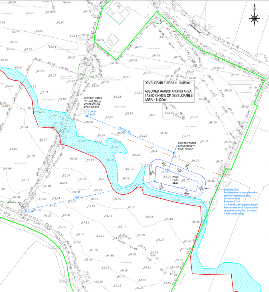
In response to this initial flood risk assessment, BSP Consulting have prepared an Outline Surface Water Drainage Strategy, shown here with further information below.
DRAINAGE STRATEGY
The existing site can be classed as ‘greenfield’ with regard to the current surface water run-off.
At present the surface water runoff flows to the River Sence which flows along the southern boundary of the site.
In line with NPPF, all development should seek to discharge at greenfield rates unless it is not reasonably practicable to do so.
The existing greenfield run-off from the site has been calculated using the method detailed within the SUDS Manual. This method calculates the runoff based upon the site’s location and soil runoff characteristics. Microdrainage modelling software has been utilised to calculate run-off rates from the site in accordance with this method.
Part H of the Building Regulations 2010 recommends that surface water runoff shall discharge to one of the following, listed in order of priority:
a. an adequate soakaway or some other adequate infiltration system, or where that is not reasonably practicable.
b. a watercourse, or, where that is not reasonably practicable.
c. a sewer.
The site investigation works have not been done but based on the sites location it is expected that the natural ground conditions will be relatively impermeable Clay and Mudstone. For this reason, infiltration will not be feasible on this scheme.
The River Sence flows east to west along the southern boundary of the site and so a discharge to the watercourse is considered to be the most feasible option for the site.
Based on the NPPF guidance the discharge rate will be restricted to achieve a rate of 4.7l/s for all storms up to and including a 1 in 100 year storm event plus 40% Climate change.
The developable area within Flood Zone 1 has been measured as 10,680m2. The assumed hardstanding area for the site, based on 60% of the developable area, is 6,400m2.
Attenuation in the form of a balancing pond will be required to store excess water during extreme storm events. MicroDrainage software has been used to calculate that 400m3 of storage is required.
The depth of the pond has been calculated based on draining a 150mm pipe from the lowest point of the site. The pond level needs to be at 64.60 which is approximately 1.4 – 1.7m below existing ground levels.
The shape of the pond has been designed so that it fits in to the area of Flood Zone 1 land south of the existing 300mm foul sewer.
A 5m easement has been allowed for the foul sewer in accordance with the requirements of STW.
The top level of the basin will tie into existing ground levels and will not require any levels to be altered within Flood Zone 2.
The proposed drainage strategy will minimise flood risk to any adjacent or downstream development up to the 1 in 100 year rainfall event, plus a 40% allowance for climate change.
The measures taken to consider the flood risk and drainage strategy for the site demonstrate that the development will be safe, without increasing flood risk elsewhere.
Landscape and Visual
LANDSCAPE CHARACTER
The Site forms a single, flat, grazing field on the built edge of Glen Parva, which forms a suburb of the wider Leicester conurbation.
Residential properties lie alongside the Site on Little Glen Road within the wider settlement of Glen Parva. To the east is a Motor Spares/Scrap yard. Adjacent to the Site, to the south, is the River Sence, and the floodplain valley landscape of grazing fields, hedges and trees, and the settlement of Blaby. To the west of the Site are agricultural fields and the embanked main line railway.
The Site and the wider landscape are not covered by any landscape quality designation at either a national or local level. The Site does not contain any rare or irreplaceable landscape features, being restricted to a few mature trees and some hedges around its perimeter. The Site does not display any pronounced sense of scenic quality, tranquillity, wildness, or remoteness. Although the surrounding landscape within the Sence valley away from the urban area has some pleasant rural characteristics, the built edges of Glen Parva, Blaby and Whetstone, together with the main railway line and roads, imparts urbanising influences on the Site and the local landscape.
The Blaby Landscape and Settlement Character Assessment (2020) defines a series of Landscape Character Types (LCTs), which are then subdivided into a series of Landscape Character Areas (LCAs). The Site and the local landscape lie within the within the large Sence & Soar Floodplain LCA.
This LCA is described as being.
“…large and varied, following the narrow floodplain of the Soar and Sence rivers which flow between the settlements to the south-west of Leicester including Enderby, Blaby, Glen Parva, Narborough, Littlethorpe and Braunstone Town. The character area is a low-intensity managed landscape with a naturalistic feel shaped by riparian vegetation and well-developed hedgerows. The edges of the character area are defined by urban development, which can detract from the landscape where there are hard urban edges.”
When considering a development scenario of “2-3 storey residential housing / transport infrastructure” and using a five-point sensitivity rating (High, High-Moderate, Moderate, Moderate-Low, Low) the Study considers the LCA- within which the Site is located -to be of no more than “moderate” sensitivity.
VISUAL AMENITY
The Site is visually well-contained within the wider landscape on account of surrounding woodland, mature trees and hedgerows – which includes woodland to the east – the built-up area of Glen Parva, and the embanked mainline railway, such that the Site has a restricted visual envelope. Views of the Site limited to localised views within its immediate vicinity.
Given the Site’s location alongside the residential edge there are opportunities for views for local residents on Little Glen Road that are opposite, albeit these are limited in extent to a few properties. There are open views of the Site from the adjacent Public Footpath which runs along the eastern perimeter and from where the route bridges the River Sence. Elsewhere, visibility of the Site from other local footpaths within the valley are prevented and obscured by intervening vegetation.
There is intervisibility between Glen Parva and Blaby with some matures trees and hedges within the intervening landscape filtering and ‘softening’ views of built elements. Views of the Site from Blaby are restricted to that of a few properties on the edge of the village. The Site, which is partially obscured by intervening trees, is observed against the backdrop of houses on Little Glen Road.
Ecology
The site is not subject to any ecological designations nor do any sites of international or national ecological significance lay nearby. There are a number of Local Wildlife Sites (LWS) within 1km of the site, but there are no impact pathways anticipated arising from the proposed development that would materially affect these designations. The site overall has limited biodiversity potential. Given the significant amount of open space planned for, it will be possible to enhance the value of the site for biodiversity through habitat creation and new planting.
Highways
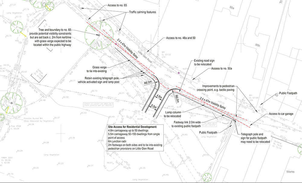
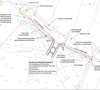
A preliminary highways assessment and proposed access design has been carried out by BSP Consulting.
The Site is located with good access to local amenities by active travel modes and public transport. There are high frequency bus services available to local centre and the city centre, and good access to rail services. There are opportunities to enhance the public right of way alongside the site and provide improved pedestrian crossing facilities on Little Glen Road.
Suitable access for pedestrians and the anticipated vehicle movements, including deliveries, refuse collection and emergency vehicles, can be provided in accordance with highway design standards. The access design will be subject to a classified traffic volume and speed survey, swept path analysis, and a Stage 1 Road Safety Audit.
The anticipated level of traffic impact is expected to be easily accommodated by the local highway network, with no requirement for mitigation measures to provide additional capacity. There are no highway safety issues currently identified or expected to occur as a result of the proposals that would justify a highway safety improvement scheme, other than ensuring that a pedestrian crossing facility is provided on Little Glen Road as part of the proposed site access arrangements.
The site is considered suitable to accommodate a residential development of the proposed scale, and a suitable scheme could be developed to meet local and national highways and transport planning related policy requirements, including policies CS10 and CS11 of the Blaby District Council Local Plan (Core Strategy) Development Plan Document (February 2013) and paragraphs 110-113 of the National Planning Policy Framework (MHCLG, 2021).
